
  Cahal PechCaracolCerros Cahal PechCaracolCerrosEl Pilar LamanaiLubaantunXunantunichAltun Ha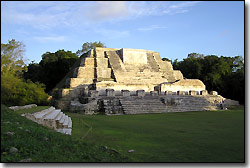 Altun Ha means Water of the Rock. It was here that the largest carved jadeobject in the whole maya area, a Jade Head, was found. This Jade Head represents the Sun God, Kinich Ahau, and can be seened in the corner of every Belizean banknote. Altun Ha was a major ceremonial center during the Classic Period (250-900A.D) and functioned as a vital trading center linking the Caribbean shores with other Maya centers. Altun Ha is located 31 miles north of Belize City. Altun Ha means Water of the Rock. It was here that the largest carved jadeobject in the whole maya area, a Jade Head, was found. This Jade Head represents the Sun God, Kinich Ahau, and can be seened in the corner of every Belizean banknote. Altun Ha was a major ceremonial center during the Classic Period (250-900A.D) and functioned as a vital trading center linking the Caribbean shores with other Maya centers. Altun Ha is located 31 miles north of Belize City.Cahal PechCahal Pech means Place of the Ticks. Cahal Pech is one of the medium sized Maya centers. It is situated along the bank of the Macal River in the Cayo District an offers visitors a panoramic view of San Ignacio and the Belize River Valley.Cahal Pech is located in San Ignacio.Caracol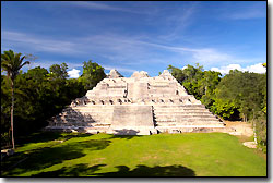 Caracol (The Snail) was discovered in 1938. In 1986, an elaborately carved stone wasdiscovered which described a victory by Caracol over Tikal. This discoverypositioned Caracol as the supreme Maya city. It's largest pyramid stands140ft (44 meters) high and is considered the tallest man made structure in Belize. Caracol is located in the Cayo district. Caracol (The Snail) was discovered in 1938. In 1986, an elaborately carved stone wasdiscovered which described a victory by Caracol over Tikal. This discoverypositioned Caracol as the supreme Maya city. It's largest pyramid stands140ft (44 meters) high and is considered the tallest man made structure in Belize. Caracol is located in the Cayo district.CerrosCerros is located in the north of Belize on a peninsula across from Corozal Town and in the Bay of Chetumal. During the Pre-Classic Period (100B.C- 250A.D), Cerros was important as a coastal trading center. During this time, Cerros expressed new forms of art and architecture that proved to be crucial for the formation of classic Maya art and architecture.El PilarThe El Pilar Archaeological Reserve for Maya Flora and Fauna is located just 12 miles (approximately 19 kilometers) north of the western town of San Ignacio, astride the Belize-Guatemala border. The ridge landescarpment where El Pilar is situated extends from Guatemala's Peteninto Belize, north of the Belize River valley.A preliminary chronology, based on ceramic comparisons, has revealedthat monumental constructions at El Pilar began in the MiddlePreclassic (500 B.C.) and continued with major remodeling completed inthe Terminal Classic (1000 A.D.). This long sequence spans more than15 centuries and testifies to a continuous and methodical developmentin the area. El Pilar has more than twenty-five identified plazas in an areaof approximately 100 acres (38 hectares), ranking it equal with major centers of the lowland Mayaregion. It is the largest center in the Belize River area, more thanthree times the size of other well-known centers such as Baking Pot orXunantunich. There are more than a dozen large pyramids and many rangebuildings. The site is divided into three primary sectors: Xaman(North) Pilar, Nohol (South) Pilar, and Pilar Poniente (West). Theeastern and western sections are connected by an offset causewaysystem extending between two large public plazas. Lamanai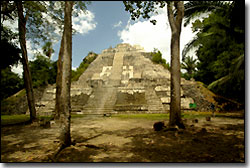 Lamanai means Submerged Crocodile. It is located in the Orange Walk district onthe New River Lagoon. Lamanai, being one of Belize's largest ceremonial centers, displays the more exotic features of ancient Maya art and architecture. Lamanai had one of the longest occupation spans, dating from 1500B.C to the 19th century A.D. Lamanai means Submerged Crocodile. It is located in the Orange Walk district onthe New River Lagoon. Lamanai, being one of Belize's largest ceremonial centers, displays the more exotic features of ancient Maya art and architecture. Lamanai had one of the longest occupation spans, dating from 1500B.C to the 19th century A.D.LubaantunLubaantun, Place of Fallen Stones, is noted for it unusual style of construction. the large pyramids and terraces are made of dressed stone blocks withno martar binding them together. The buildings on top of the pyramids were made of perishable materials and hence no longer remain. Lubaantun is located in Punta Gorda, Toledodistrict.Xunantunich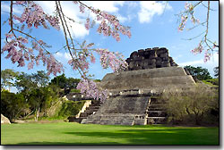 Xunantunich (pronouned Su-nan-tu-nich) means Maiden of the Rock. It is the second tallest Maya ruin in Belize and is located across the river fromthe village of San Jose Succotz in the Cayo district.It stands 130ft (40 meters) high and gives a panoramic view of the Cayo Districtand Guatemala. Xunantunich was a major ceremonial site, built on a natural limestone ridge during the Classic Period. On the eastern side of one of the largest pyramid "El Castillo" is a frieze. The central mask represents the sun god, flanked by signs representing the moon, Venus, and different days. Three carved stelae found at Xunantunich are on displayin the plaza. Xunantunich (pronouned Su-nan-tu-nich) means Maiden of the Rock. It is the second tallest Maya ruin in Belize and is located across the river fromthe village of San Jose Succotz in the Cayo district.It stands 130ft (40 meters) high and gives a panoramic view of the Cayo Districtand Guatemala. Xunantunich was a major ceremonial site, built on a natural limestone ridge during the Classic Period. On the eastern side of one of the largest pyramid "El Castillo" is a frieze. The central mask represents the sun god, flanked by signs representing the moon, Venus, and different days. Three carved stelae found at Xunantunich are on displayin the plaza. |